Leaderboard


Popular Content
Showing content with the highest reputation on 01/11/2024 in all areas
-
We are heading there on Sunday, I will post a report after our ride, Hopefully they get the snow in the forecast they are calling for.6 points
-
You might as well sell the sled. Polish up your lawn mower.. You aren't sledding with out trailering. It would likley help your blood pressure... Unless a loop around your farm is what it's all about for you..3 points
-
Sleds are coming outa the backyard shed and thru the gate tomorrow, pretty much same time frame as always.3 points
-
Darn, that might spoil beating your 75 km. on private land in 2023.2 points
-
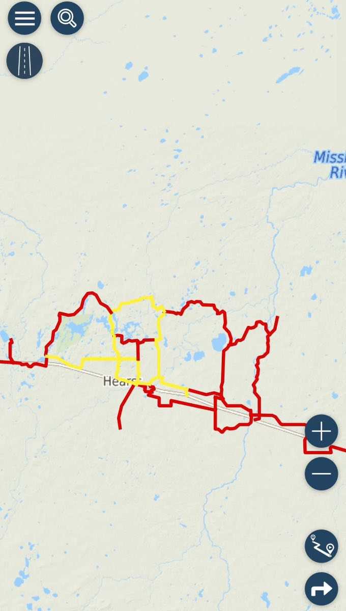
I just read that Missing Links groomer has been out today and if they get the snow predicted tonight they will likely open very soon.2 points
-
2 points
-
Getting a little here and there. Single digit Fahrenheit temps, helping freeze things up. Ski

 2 points
 -
At 15,000 sleds, each rider spending say 200 $ per day , give or take . That is a descent win fall for the local economy . 3 Mil per day ,NICE ,2 points
-
Let the games begin1 point
-
But just north of us in Dist 9 they are calling for 10-15 cms Friday, 10 cms Saturday, 5-10 cms Sunday and 1 mm rain. Hoping they get it all and more near the lakes.1 point
-
The guy that came up with that # was probably 15 beers deep . And sleep deprived .1 point
-
Would like to hear the updates for sure - it will be nice to scratch the itch maybe next week and the forest is a good spot for that while the OFSC trail system hopefully comes to life!1 point
-
Forecast actually looks promising fingers crossed we actually get it1 point
-
It's hailburton forest, it's a private trail network. They have summer access roads that make up main trail network. They are smooth to start with, so they can open with less snow then surrounding area. They always jump gun by sounds of it, it hasn't all been groomed yet if any at all. Says they be heading out when temperatures drop 😎 https://www.haliburtonforest.com/trail-conditions/1 point
-
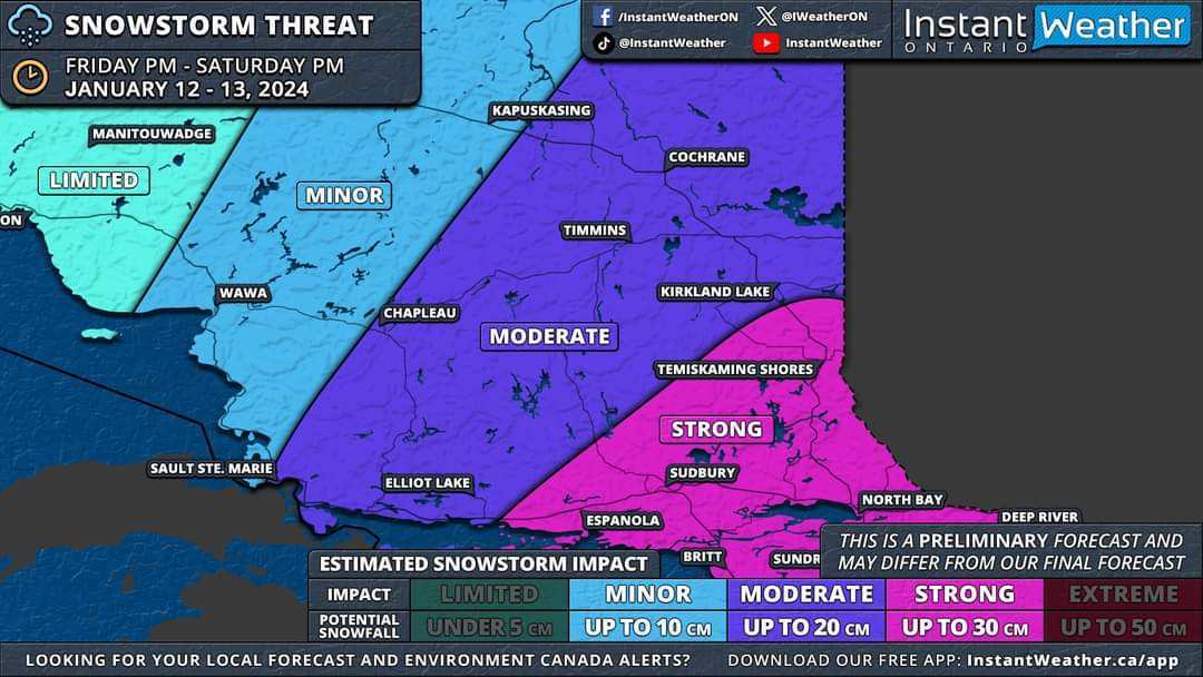
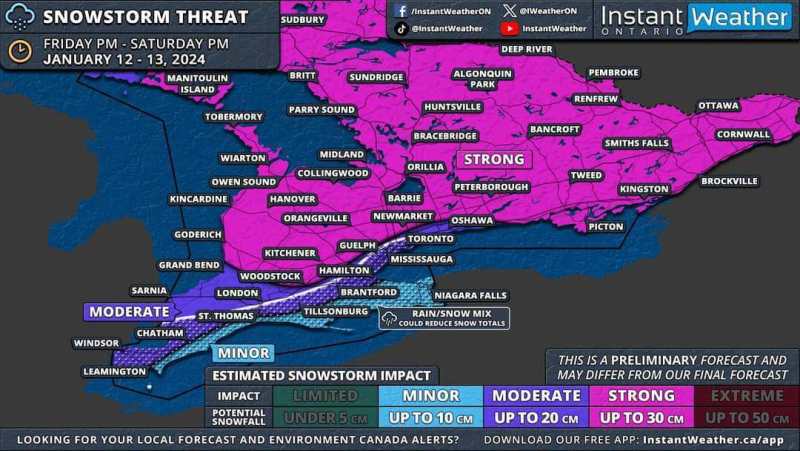
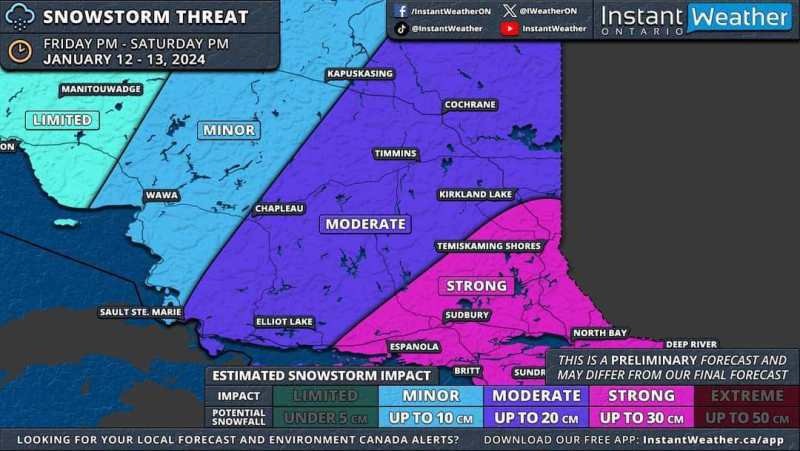
Friday Night storm update. ❄️ SNOWSTORM PREVIEW: Widespread Significant Snowfall of Up to 30cm on the Way for Most of Southern & Northeastern Ontario 📅 Friday, January 12 - Saturday, January 13, 2024 —— After reviewing the latest model data from this evening, it appears increasingly likely that Southern Ontario will experience its first widespread significant snowstorm of the season starting Friday. We'll publish a detailed forecast article in the morning. For now, here's an early look at the forecast maps based on this evening's model runs. Remember, this forecast is preliminary, as the storm is still about 36 hours away. Although there's time for model adjustments, any changes should be minor given the high confidence in this event. Before Friday's main event, a weaker system will pass through Southern Ontario on Thursday morning and afternoon. While significant accumulation isn't expected, a few centimetres may cover Central and Southwestern Ontario, including the Greater Toronto Area. Lake enhancement east of Lake Huron could increase totals to 3-6cm in the Owen Sound to London corridor, tapering off by late afternoon. The main storm is expected to start between 2-5 PM on Friday, beginning in Extreme Southwestern Ontario. Initial bands could bring heavy snowfall, with rates of 5-10cm per hour, and the potential for thundersnow, a phenomenon we haven't seen since last winter's major blizzard. ⚡️ Strong wind gusts of 60-80km/h, locally reaching up to 90km/h, will likely create treacherous driving conditions. Areas might experience localized blizzard conditions, especially in Southwestern Ontario, the Golden Horseshoe, and parts of Central Ontario. These heavy snowfall rates will move through Southwestern Ontario, affecting London, Kitchener, and Hamilton by early evening. The Greater Toronto Area will experience this intense snow later in the evening, eventually spreading northeast to Central and Eastern Ontario, continuing overnight into early Saturday. While the heaviest snowfall will be brief, moderate snow will persist behind the initial band throughout the night into Saturday. Around the Lake Ontario and Erie shorelines, a brief surge of warmer air Friday night into Saturday morning could lead to a temporary changeover to rain, potentially reducing snowfall totals in the Niagara region and parts of the Greater Toronto Area near the lakeshore. A sharp cooldown early Saturday morning will bring temperatures back below freezing, switching precipitation back to snow and creating a risk of flash freezing. Icy road conditions are likely on Saturday morning. By Saturday's end, most of Southern Ontario, excluding Deep Southwestern Ontario and the Niagara region, can expect 15-30cm of snow. The Lake Erie shoreline and Niagara region are projected to receive 5-15cm, while the Greater Toronto Area could see 10-20cm, with higher amounts further from the lakes. This event will also affect Northeastern Ontario with over 20cm of snow on tap for Sudbury, North Bay and Temiskaming Shores starting late Friday evening and continuing through Saturday. As the system exits, lake effect snow will intensify late Saturday around Lake Huron and Georgian Bay, with snow squalls likely into next week. This could result in substantial snowfall over the week in areas like Goderich, Kincardine, Hanover, Owen Sound, Wiarton, Barrie, Orillia, Midland, Bracebridge, Huntsville, Parry Sound, Britt and Sundridge We'll provide more details in our full forecast article on Thursday morning and a final forecast with precise totals either Thursday evening or Friday morning. - Brennen
 1 point
 -
Just because they "say" its open doesn't mean its ready to ride.1 point
-
Yeah killing Ontario no doubt. It's a little concerning.1 point
-
We were in Valin in March 2020 and saw 20 sleds in 4 days lol. It was awesome1 point
-
100 plus season pass holders, But still not comparable. It won't be 350km this weekend not a chance.1 point
-
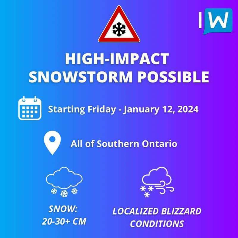
Another storm is heading our way ⚠️ Get Your Shovels, Southern Ontario! The First Major Snowstorm of the Season Is on the Way This Weekend ❄️ 📅 Friday, January 12 - Sunday, January 14, 2024 🔗 https://instantweatherinc.com/ontario/forecast/2024/1/10/snowstorm-preview —— Confidence is growing in a strong system set to sweep across Southern Ontario starting Friday and persisting throughout the weekend. In contrast to previous weather systems, this one looks likely to keep most of the region on the snowy side, leading to widespread and substantial snowfall. Although there's always a chance for last-minute changes, it's nearly certain that parts of Southern Ontario are in for a heavy snowfall this weekend. The onset is expected sometime Friday afternoon, continuing into Saturday. We're still finalizing the exact details, but a more detailed preliminary forecast will be available later today. Currently, we anticipate general snowfall totals in the range of 20-30cm across a broad area of Southern Ontario, extending from the Southwest through the Greater Toronto Area and into Central/Eastern Ontario. Almost everyone in these regions should brace for significant snowfall. In some localities, particularly around Lake Huron and Georgian Bay, totals could surpass 30cm, boosted by lake-enhanced snowfall. The combination of intense snow and potentially strong, damaging wind gusts of 70-90km/h could lead to complete whiteouts. We can't discount the possibility of blizzard conditions, especially in Southwestern Ontario. The main area of uncertainty lies along the Lake Ontario shoreline and in the Niagara region. Some forecasts suggest a brief switch to rain overnight on Friday, followed by a return to snow on Saturday. This could result in lower snowfall amounts near the shoreline, heavily dependent on the storm's exact path. The latest data shows a trend towards a westward path, which could introduce warmer air into the region. Another aspect we're watching closely is the potential for significant lake effect snow following the storm, starting Sunday and possibly extending into the week. This could lead to remarkable snowfall accumulations in typical snowbelt areas such as Grey-Bruce, Simcoe County, Muskoka, and Parry Sound. By week's end, some of these areas might be measuring the snow in FEET (1 ft = 30cm). In summary, the upcoming week promises to be a hectic one, but we're prepared and will keep you updated with in-depth information around the clock. Stay tuned!
 1 point
 -
We got about 5” of snow on Lake Nosbonsing, near North Bay.1 point
-
1 point
-
A close friend of mine owned a multi generation mid sized transport compamy and 25 years or more ago Petro Canada approached him wanting to do an oil testing program. At the time the heavy haul fleet with loaded weights in the 123,000 - 139,500 lb. range operated all over Ontario and in Quebec and Michigan. When the testing started the trucks were on a 15,000 km. change interval. Petro Canada supplied the 15W40 non synthetic oil for the cross section of trucks they were testing and took samples for testing at different periods and were there to take samples at oil change time. Those samples were tested and my friend received copies of all the test results. If engines in the participating trucks were torn down for any reason, Petro Canada inspected the engine parts involved. Petro even had at least one high mileage engine that hadn't failed torn down for inspection. Over the years of testing the results were so encouraging that the change intervals were extended on trucks and the last I remember the change intervals for the whole fleet were at 40,000 km. There was never any pre mature oil related failures on the sampled engines that I remember. They used good name brand filters but I don't remember if they did filter changes midway therough the change intervals or not. I'm pretty certain that there are fleets out there presently operating on 50,000 + km. oil change intervals but those are not likely heavy haul.1 point
-
Searchmont Updates For those who may not have not sledded through Searchmont in the past winter or so, the Searchmont Resort has built a very nice dining area and bar, named the Kiln. You may find it handy on your ventures through the region. https://searchmont.com/the-kiln/1 point
-
Just need two friends and a snow rake lol
 1 point
 -
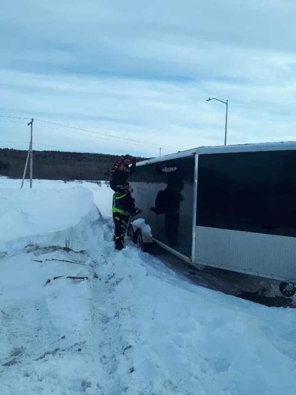
Most times, when my trailer is parked at home, I have it so it is tilted forward as much as possible and the snow tends to slide off the top, down the front and makes nices piles of snow beside the tongue that I need to shovel away...... Alternately, since I do not store sled inside of trailer, I lift tongue in the air until the rear of trailer touches the ground and all snow slides off the back. My trailer is a TC118 so I can tilt/lift my trailer by hand like this. If I am away and this happens while parked, I try to get what I can off with snow brush and the rest usually comes off as I drive down the first few km of road.1 point
-
Roof rake.. I keep one in the trailer. Always there when you need it..1 point
-
A couple of buddies of mine are in Mont Valin right now its so full they have to stay an hour away and trailer there every day from their hotel.0 points