LuvMyViper
-
Posts
7,823 -
Joined
-
Last visited
-
Days Won
219
Content Type
Profiles
Forums
Gallery
Everything posted by LuvMyViper
-
Maybe $165,000 will be the price of their new sled in the future..
-
How bout get a room at The Deerhurst Resort. Ride from there small loops..
-
That's impressive 👏
-
It was a pleasure meeting Bob and I always enjoyed his postings. Condolences to his friends and family
-
Does EJs in Baden still have great wings?
-
Thanks Ambassador Nunz!
-
Congrats!!!!! Enjoy.....
-
It's the Bonnie Fortin that works at Home Hardware when you do a Facebook search
-
Any suggestions? I've tried everything... Money and alcohol
-
Copied from a website... The Unprecedented Winter Shift Of 2024 (Video) We are now seeing the beginning of half a year or a years worth of snow in a single storm across the N. Hemisphere and we are only in late autumn. Moving from record floods of the summer into winter, convert the water equivalent of one inch of rain equaling one foot of snow and we are looking at unprecedented possible snow depths. Here is where it has happened already.
-
Welcome to the forum JIMMXZ. Happy Trails
-
Let it Snow.... Let it Snow... Let it Snow!!!!!
- 1 reply
-
- 3
-

-
Last night my friend told me that his son is selling is sled because there's no snow anymore. He lives in Timmons. That's not good..
-
#MeToo..... that's why I got divorced
-
It's hotter than a hookers door knob on nickel night today!!!!
-
2025 Polaris Snowmobiles revealed at 7pm tonight EST.

-
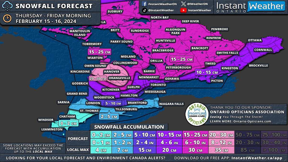
February 15th Snowstorm Update ( The system will approach from the west during late Thursday morning, initially impacting areas around Lake Huron before spreading eastward through the afternoon. Deep Southwestern Ontario, including Windsor, Chatham, and the Lake Erie shoreline, might start the day with mixed precipitation, including freezing rain, before transitioning to rain as temperatures rise. By the afternoon, heavy snow will extend across Central Ontario and into the Golden Horseshoe. There remains some uncertainty regarding the extent of mixed precipitation to the north. Consequently, areas closer to the shoreline, such as Hamilton, Burlington, Brampton, and Toronto, may see some mixed precipitation which would reduce the snowfall totals here. Central and Eastern Ontario will continue to experience snowfall into Thursday evening. The most challenging conditions are expected during the late afternoon and early evening when both wind and snowfall rates will be at the strongest. The system is anticipated to gradually exit the province shortly after midnight. However, lake effect snow may develop off Lake Huron and Georgian Bay, with a particularly strong squall likely between Owen Sound and Kincardine overnight. Although expected to weaken by Friday morning, lake-effect snow may still linger throughout the day, especially in Huron, Wellington, Grey, and Bruce counties. This system will also impact southern parts of Northeastern Ontario, with Elliot Lake, Sudbury, and North Bay set to receive 15 to 25cm of snow. The rest of Northeastern Ontario, including Sault Ste. Marie, Chapleau, Timmins, and Cochrane, can anticipate 5 to 15cm. Northwestern Ontario, including Thunder Bay, is expected to see less than 5cm of snow. https://instantweatherinc.com/ontario/forecast/2024/2/14/snow?fbclid=IwAR0rfk9m-KadpH2BdmxOQP_qvMwodw1bYtw9MX5qjlLxY1Aym_HKLZLoaxQ

-
And Swifties on the forum?
-
There's two types of people in the world..... people who admit they like Nickelback, and people who are liars
-
Unless you're being attacked by a moose or bear and your riding buddy has one in his bag
-
And the 80s were even blurrier !!!! I miss those days..
-
I would agree with you but then we'd both be wrong
-
There might be some good news for the middle of February pattern change. How weather patterns are expected to change across the United States in February The Weather Will Be VERY Different In February... Max Velocity - Severe Weather Jan 27, 2024 In this weather forecast, we are breaking down a DIFFERENT weather pattern that will change the weather for February comparably to January. Arctic blasts, winter storms, and severe weather will all be possible throughout the month, but exactly when will these events ramp up? This weather pattern is a part of El Nino, which has led to more active weather in the Southern Tier of the USA, while the Northern Tier has been less active. This will lead to some snow events, showers and storms, and perhaps severe weather. Find the latest details of the weather across the United States in our latest weather forecast. .
-
And I thought it was something I said lol. Welcome back!! Great to see you return!!!