barberch
-
Posts
529 -
Joined
-
Last visited
-
Days Won
7


-
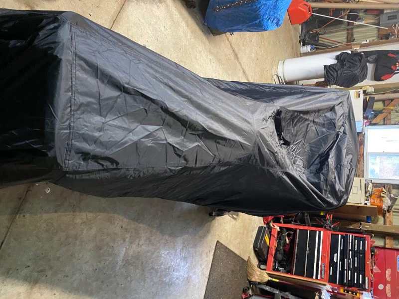
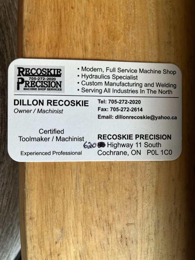
I wanted to give a shoot out to Dillon at Recoskie Precision Machine Shop in Cochrane. While riding up there in March, I threw a stud and it went through my heat exchanger. Mike from sledaddicz , made a couple phone calls for me and Dillon was highly recommended. I went directly to his place just south of town and he took me right in and started the repair. In no time, it was all fixed and back together and I was on my way only losing half day of riding!

-
Got an email today that says my permit has been shipped!
-
I agree. No matter whether you use trakmaps or a paper map or the hand drawn map you made last year, the online map is the only source for current status. I think eliminating the paper maps and map boards would further show all landowners the OFSC commitment.
-
Agreed. Trakmaps is very similar to the paper trail guide. There isn’t a lot of detail and the interactive trail guide must be used as the only source for trail status.
-
I will gather some up and drop them off at the OFSC and make sure they are aware that using the maps could lead to people riding on closed trails.
-
Much like a paper map. Nice to have but not a necessary item.
-
Exactly! While using Trakmaps, the online status can still be checked daily too!
-
I sure hope there are no paper maps found being given out by the Clubs/ Districts/ OFSC at the snowmobile shows this year. It would be terrible if a rider was using the paper maps and riding on closed trails because they didn’t check the online status.
-
I wonder where the data came from that confirmed that the reason people are riding on trails that are closed is because they are using tools like Trakmaps? When i use Trakmaps to plan my route, I always refer to the ITG to ensure the trail is available.
-
It’s hard to imagine how the OFSC can think this is a good thing to do. They tell us all the time that the ITG is the only source for trail status but feel this is the right thing to do. I guess their method of communication of the source of trail status must be a failure. I assume all paper maps will cease to exist as well as any maps that are posted on sign boards at clubhouses and at locations on the trail. Next thing they will think we have to install gates that can only be operated by paid members on each trail to keep non members out! It will be another inconvenience for the membership. I believe the membership should send an email to let them know how we feel about it.
-
sad to hear. I have been using Trakmaps for years planning my routes and they are awesome! Hopefully something can be worked out...
-
I have one. It works great! It does have to be plugged in to keep the shield clear when colder. I have been able to wear my glasses while using it too. When I start out i leave it open a bit to clear the shield and then I am good to go. I did use it one warmer day and did not plug it in and it worked great too. I am in a XXL and it fits good. When i tried the Oxygen, I would need a XXL. The Contact is very quiet too. I am very happy with it so far. Mine was $270 out the door !
-
a bit of both. Up from the clubhouse, over through Wilberforce and up the 601 to the E. I did the Mink Lake trails off the 109 and then over to the rail trail just above lake St Peter. Then I took the 109 back to the E and back to the clubhouse.
-
trails from the Paudash clubhouse up to Lake St Peter were in great shape today! The road running was fine too!
-
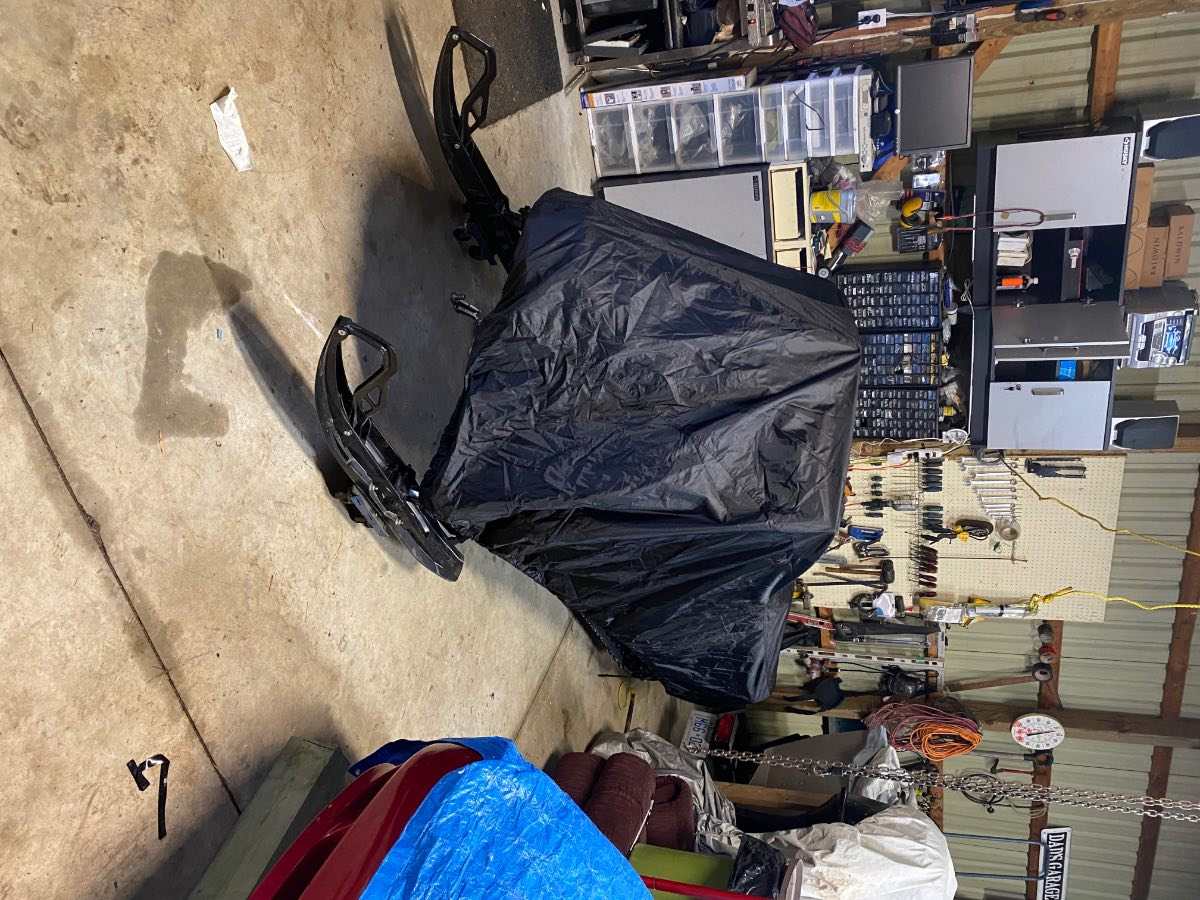
I bought one from these guys at the Toronto sled show. https://outdoorcovers.ca/snowmobile-covers/