willb
-
Posts
86 -
Joined
-
Last visited
-
Lots of snow but lots of sled traffic so trails were rough on the weekend but all good.
-
Where is your cottage? We have a place near the Maclean lake boat launch.
-
I do not know the details of the new ownership or the transfer. Just was told new owners last year and now see the new website. Only can go up though!
-
New owners fully now (a positive in my eyes) and they have a new website. https://www.sledabitibi.com/?fbclid=IwAR1YU8FDuOVCqhWCbsIT4LiKIqOojLseDMH9MY8zWsF_AbTaibBDSmQFHaE I can only assume that they will have fuel like previous years but can’t personally confirm. Send Steve a message on Facebook or email or call (info on the website).
-
Like mentioned above it would be ideal that the OFSC presents the data they have that stopping usage of track maps is going to lower trespassing. No other places (states, provinces, etc) to my knowledge are doing this? It just seems the OFSC continues to take these stances that blindside members and offer less services for them. For anyone involved in the OFSC was this discussed at district meetings or the AGM? Or with landowners? I have the file now so should be good for a little bit…
-
The big reason I want a smaller stackable caddy (don’t care if it’s oil or gas) is to save weight and bulk. 16l can be fit into the stackable fuel caddy plus the 4l of oil stacked on it in the small caddy and that adds up to about 45 lbs of extra weight at the rear (including the caddy weights) plus your gear. Not to mention the extra size of the stacked cans which is applicable if you are riding off trial. if they made the small caddy stackable that would be enough gas and oil but only half the weight and 2/3 of the height/size. hope they are working on it!
-
The road to the base camp is “hwy” 634 running from smooth rock. It only crosses the river at the top via the actual dam. “hwy” 579 is the one that crosses the via the gardiner ferry from Cochrane. Not sure where it goes, looks like to some camps and lakes. But maybe some development was back there at one time?
-
Ha! But it is only regular. Either way there are no roads to town besides the ice road. I was told that gas travels by the train up to Moosonee when we were there. So way better deal for fuel in Moosonee!
-
Great thank you for the information. We have backcountry’s so sounds perfect!
-
Are there elevation changes and lots of backcountry riding options out of there? Would love to hear more!
-
Agreed! I am sure the ofsc is doing some good work on this front, but some transparency from the ofsc on what solutions are being looked at and some details rather than we just closed trails would be welcomed!
-
I agree with the comments above around a better plan for clearing the road and a long term plan for the place being needed. I have been to halfway and it is an interesting spot and am thankful of the people who worked hard to keep it open in the past. But without that ‘one’ family or group of people to operate it, it is a tough proposition. Ultimately I hope the trails can stay open without halfway. As a rider with a fuel caddy I can make it 200 kms pushing snow so a second caddy would make the trip doable (maybe not for everyone but still possible). In either case I wish the rider could make the call to go or not rather than the ofsc just closing the trails fully. There are trails in QC that have no fuel for ~230 kms and still open (La dore to Chib. as one example). so I wonder what it would take to groom those trails with out halfway? Quebec seems to groom trails that are this remote without gas so why can’t ON? Wonder what solutions we can come up with without halfway? Maybe the club can find an alternate fuel solution and operator support plan? Can we not put a larger fuel tank on the groomer? Etc. Anyway enough armchair quarterbacking from me…
-
Worth phoning some local dealerships to see if they would trailer you around for a fee or even the club or some local towing companies. Might not want to do it as a business but you could find someone willing to do a one off for a few bucks. Good luck!
-
FYI. https://abitibicanyon.com/extreme-tours-moosonee
-
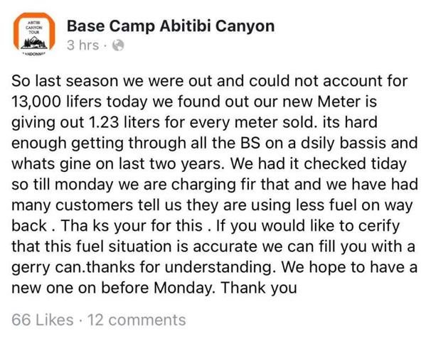
I would like to see the cost of fuel they pay. I suspect it could be lower than what we all think. I think they would be shut down if they were not making money. In fact they keep growing and investing in the place (new tank, tours, renos, places to stay, etc.). I don’t complain about the cost; it is what it is and I am happy to support them when I do. Anyway, I am thankful the guys are there and open and part of keeping this trail what it is. With that said this post on FB right here basically sums the operation up.