


LuvMyViper
-
Posts
7,391 -
Joined
-
Last visited
-
Days Won
158
Content Type
Profiles
Forums
Gallery
Posts posted by LuvMyViper
-
-
1 minute ago, Spiderman said:
Interesting, I have a buddy right on the water in Long Point - was just texting him and he said it's definetly pretty nasty there right now - but it's been worse in terms of the water and wind - but also said it's only really just starting.
I think the winds are really just today - as the 2 fronts connect - it will die down and then more snow will fall
My friend is in Port Rowan. Water front on top of the bluff.. I hope your friend stays safe... The power goes out all the time down there, gonna be interesting today
-
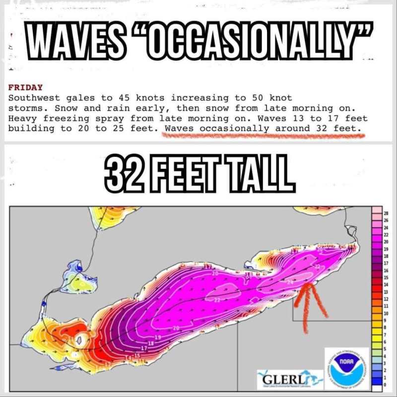
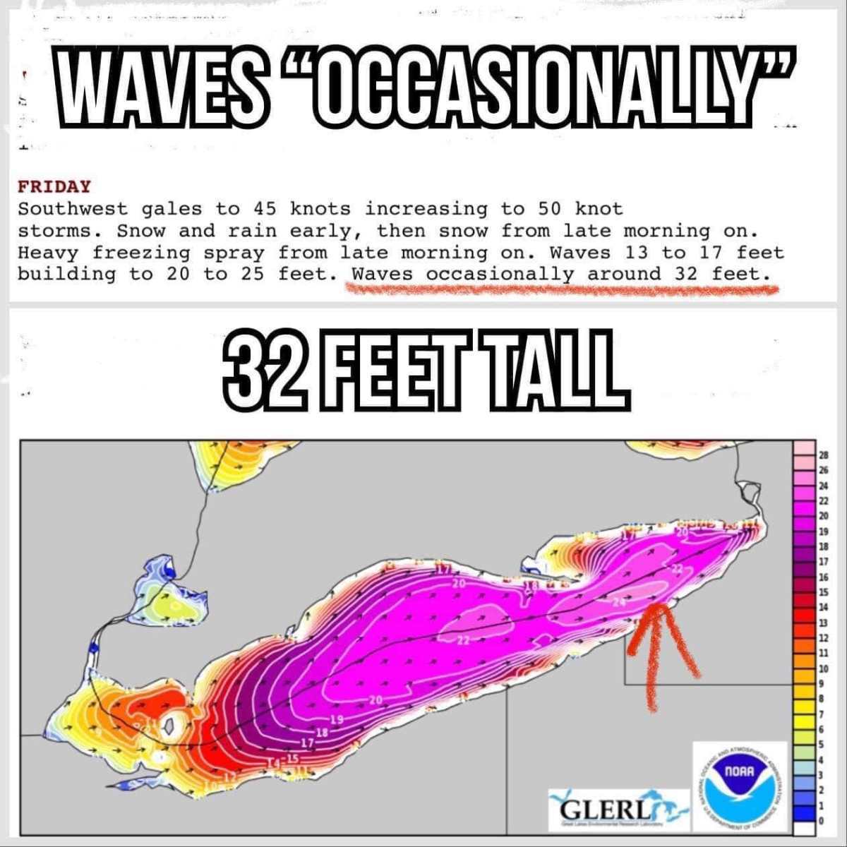
i just got a report from Port Rowan (Long Point Bay) and it's snowing/blowing so hard you can see your hand. The water in Long Point Bay is leaving and the bay will be empty soon. The water is heading to Buffalo and will come back in a wall that will flood the North Shore of Lake Erie. My friend said he's never seen it this bad before (born there) and the snow and wind will be increase as the day goes on. And 30 plus foot waves on Lake Erie
-
 1
1
-
-
50 minutes ago, signfan said:
What's everyone seeing on the ground. Was this a big flop again?
The storm is starting as advertised here in Kitchener. Snowing pretty hard since around 7:30am and the temps are dropping quickly along with strengthening winds. We didn't get much rain (max temp was +1C today). Pictures at 11
-
-
5 minutes ago, Sledguy74 said:
Lots of wind and minimal snow so far in KW
It's blowing pretty hard in the Kitchener (by Fairview Mail) in the last hour. Visibility is greatly reduced too.
-
1
-
-
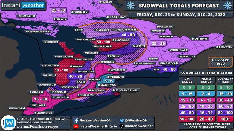
Here's an update from Instant Weather Ontario
‘Crippling’ Blizzard to Put a Damper on the Holiday Weekend in Parts of Southern Ontario With Up to 100cm of Snow Possible
-
1
-
-
It’s going to get rough Lake Erie today!!! Mega Walleye chop
-
 1
1
-
-
Warnings
6:48 AM EST Thursday 22 December 2022
Blizzard warning in effect for:- Mount Forest - Arthur - Northern Wellington County
Crippling blizzard Friday into Saturday.
Travel will become dangerous and is not advised.
Hazards:
Blizzard conditions with wind gusts of 90 to 100 km/h.
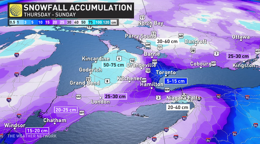
Snowfall amounts of 25 to 50 cm by Sunday morning. Additional snowfall is possible Sunday.
Wind chill values into the minus 20s.
Flash freeze producing icy and slippery surfaces.
Timing:
Strong winds and blizzard conditions developing Friday morning and continuing into Saturday.
Very cold wind chills are expected to develop Friday and persist into the weekend.
Flash freeze possible Friday morning.
Discussion:
Precipitation may begin as rain or snow late this afternoon before transitioning to rain in many areas tonight. Temperatures are expected to plummet on Friday morning leading to a potential flash freeze for locations that receive rainfall. Rapidly falling temperatures will be accompanied by strong to damaging winds along with snow heavy at times. Blizzard conditions will develop Friday morning. Lake effect snow will result in variability of snowfall amounts through the weekend.Visibility will be suddenly reduced to near zero at times in heavy snow and blowing snow. Protect yourself from wind, cold and disorientation by staying sheltered, indoors or with your vehicle. Anyone who is not dressed warmly is at risk of frostbite and hypothermia in cold weather. Ensure that shelter is provided for pets and outdoor animals. Public Safety Canada encourages everyone to make an emergency plan and get an emergency kit with drinking water, food, medicine, a first-aid kit and a flashlight. For information on emergency plans and kits go to http://www.getprepared.gc.ca.
Please continue to monitor alerts and forecasts issued by Environment Canada. To report severe weather, send an email to ONstorm@ec.gc.ca or tweet reports using #ONStorm. -
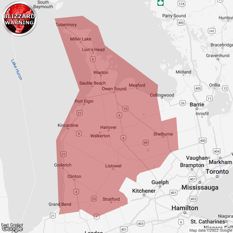
Blizzard Warning
Environment Canada(Locations listed below description)
Crippling blizzard Friday into Saturday.
Travel will become dangerous and is not advised.
Hazards: Blizzard conditions with wind gusts of 90 to 100 km/h. Snowfall amounts of 25 to 50 cm by Sunday morning. Additional snowfall is possible Sunday. Wind chill values into the minus 20s. Flash freeze producing icy and slippery surfaces.
Timing: Strong winds and blizzard conditions developing Friday morning and continuing into Saturday. Very cold wind chills are expected to develop Friday and persist into the weekend. Flash freeze possible Friday morning.
Discussion: Precipitation may begin as rain or snow late this afternoon before transitioning to rain in many areas tonight. Temperatures are expected to plummet on Friday morning leading to a potential flash freeze for locations that receive rainfall. Rapidly falling temperatures will be accompanied by strong to damaging winds along with snow heavy at times. Blizzard conditions will develop Friday morning. lake effect snow will result in variability of snowfall amounts through the weekend.
Visibility will be suddenly reduced to near zero at times in heavy snow and blowing snow. Protect yourself from wind, cold and disorientation by staying sheltered, indoors or with your vehicle. Anyone who is not dressed warmly is at risk of frostbite and hypothermia in cold weather. Ensure that shelter is provided for pets and outdoor animals. Public safety Canada encourages everyone to make an emergency plan and get an emergency kit with drinking water, food, medicine, a first-aid kit and a flashlight. For information on emergency plans and kits go to http://www.getprepared.gc.ca .
Please continue to monitor alerts and forecasts issued by Environment Canada.
To report severe weather in Ontario, send an email to onstorm@ec.gc.ca or tweet reports using #ONStorm.
ISSUED:
- Arthur
- Blue Mountains
- Bluewater
- Blyth
- Bruce Peninsula
- Dundalk
- Goderich
- Grand Valley
- Hanover
- Kincardine
- Listowel
- Mansfield
- Milverton
- Mitchell
- Mount Forest
- Northern Dufferin County
- Northern Grey County
- Northern Huron County
- Northern Perth County
- Northern Wellington County
- Orangeville
- Owen Sound
- Sauble Beach
- Saugeen Shores
- Shelburne
- Southern Bruce County
- Southern Dufferin County
- Southern Grey County
- Southern Huron County
- Southern Perth County
- Stratford
- Tobermory
- Wingham
https://instantweather.ca/2022/12/22/OfMe8M-blizzard-warning-replaces-winter-storm-watch/
-
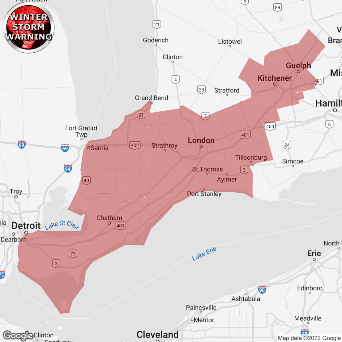
Winter Storm Warning Replaces Winter Storm Watch
Environment Canada(Locations listed below description)
Major winter storm expected Friday into Saturday.
Hazards: Wind gusts of 90 to 100 km/h creating widespread blowing snow which will significantly reduce visibility. Snowfall amounts of 5 to 15 cm by Friday night. Wind chill values into the minus 20s. Flash freeze producing icy and slippery surfaces.
Timing: Damaging winds developing Friday morning and continuing into Saturday. Snow and extensive blowing snow developing Friday morning and continuing into Saturday. Very cold wind chills are expected to develop on Friday and persist into the weekend. Flash freeze possible Friday morning.
Discussion: Precipitation is expected to begin as rain or snow late this afternoon or early this evening before transitioning to rain for many areas tonight. Temperatures are expected to plummet on Friday morning leading to a potential flash freeze. Rapidly falling temperatures will be accompanied by damaging winds along with snow, heavy at times. Extensive blowing snow will develop Friday morning.
Consider postponing non-essential travel until conditions improve. Visibility will be suddenly reduced to near zero at times in heavy snow and blowing snow. If visibility is reduced while driving, slow down, watch for tail lights ahead and be prepared to stop. Public safety Canada encourages everyone to make an emergency plan and get an emergency kit with drinking water, food, medicine, a first-aid kit and a flashlight. For information on emergency plans and kits go to http://www.getprepared.gc.ca .
Please continue to monitor alerts and forecasts issued by Environment Canada.
To report severe weather in Ontario, send an email to onstorm@ec.gc.ca or tweet reports using #ONStorm.
ISSUED:
- Aylmer
- Cambridge
- Chatham-Kent
- Eastern Elgin County
- Eastern Lambton County
- Eastern Middlesex County
- Erin
- Essex County
- Guelph
- Kitchener
- Komoka
- Leamington
- London
- Oxford County
- Parkhill
- Petrolia
- Pinery Park
- Region Of Waterloo
- Rodney
- Rondeau Park
- Sarnia
- Shedden
- Southern Wellington County
- St. Thomas
- Strathroy
- Tillsonburg
- Watford
- Western Elgin County
- Western Lambton County
- Western Middlesex County
- Windsor
- Woodstock
https://instantweather.ca/2022/12/22/Qva55w-winter-storm-warning-replaces-winter-storm-watch/

-
1
-
The Godfather of winter weather Joe Bastardi tweeted this 7 hours ago about this storm.
been a long time since we have seen this much widespread snow before Christmas and this amount of cold centered on Christmas. Rare event The pre Christmas tandem of Winter storm Michael Scott Threat Level midnight from the west and Sideshow Bob to the east leave us with this
-
1 hour ago, Spiderman said:
Diesel are polluters - too focused on saving the environment here - meanwhile in other parts of the world - their interest level in saving the environment is less than 0.
They make huge money from the environment while destroying it and having us pay for it... imo
-
-
Just now, UsedtoSkidoo said:
well actually it was28%..................lol
I was being nice
")
-
1
-
-
1 hour ago, SlowTouringGuy said:
LMV that would be awesome. I’d only to see the 16,000 posts of mine that disappeared !
The forum was attacked and all data/backups were destroyed back then and NoBackupGuy that was hosting the forum wasn't Magic Marty. That was a real shame

-
24 minutes ago, UsedtoSkidoo said:
Thats why i dont do it. I have the bladder of a 6 year old
Not my problem. You dont cut off your leg when you have an in grown nail
I would bet that if they allowed it 99% of the people would be smart and exercise proper judgement.
True but 50% of the population has VERY poor judgement abilities...
-
8 minutes ago, Ox said:
Link comes up as a blank page for me.
(but I git the gist of it by now)
.
The link works for me..
-
11 minutes ago, Krusty said:
Thanks for the info, much appreciated!
Have fun!!!!! Where ya think you're going?
-
10 hours ago, killswitch said:
sadly no, ran out of people in the area to sled with and didnt have a trailer anymore. Cant wait to get back into it when i can!
I hope some day when you have snowmobile, you take us out on a Killswitch Lake Tour.... You would have many followers
")
-
1
-
-
20 minutes ago, killswitch said:
It was a faster sled🤷♀️ what can i say i inherited the speed gene.😂
Are you still riding?
-
Here's two old threads I found (I had to remove the https:// so it would be postable, no idea why)
Doonut's unofficial OC.com Muskoka Lakes Tour from (2008)
ontarioconditions.com/forums/index.php?/topic/1240-doonuts-unofficial-occom-muskoka-lakes-tour/
Thanks Doonut (2008)
ontarioconditions.com/forums/index.php?/topic/1386-thanks-doonut/
-
10 hours ago, UsedtoSkidoo said:
I was being nice.
#MeToo
-
3 hours ago, killswitch said:
Thank you all so much!!
You are very welcome
-
Awesome!!! Thanks for sharing.. Loved the video
-
1
-


Snow event on the way? March 3-4
in Main Clubhouse
Posted
Just a heads up to all living in the Norfolk County area or have travel plans in or through the area... the county has pulled the plows off the roads... please stay at home. Roads are not officially closed at this point, but if and when the OPP does close them, just a reminder that your car insurance may not be valid when driving on a closed road.