LuvMyViper
-
Posts
7,391 -
Joined
-
Last visited
-
Days Won
158
Content Type
Profiles
Forums
Gallery
Everything posted by LuvMyViper
-
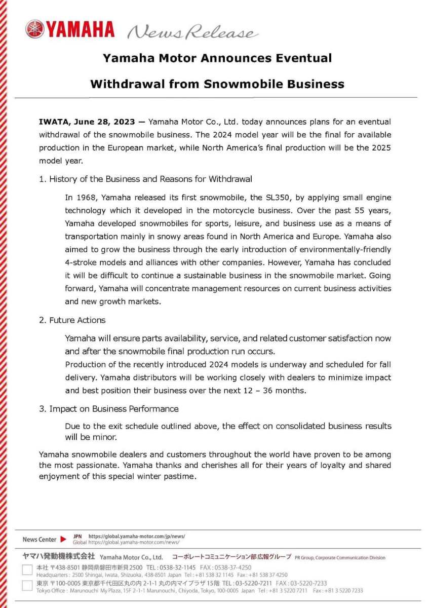
Yamaha to stop producing snowmobiles after 2025 season
LuvMyViper replied to LuvMyViper's topic in Main Clubhouse
Or a Ford lol...
-
Yamaha to stop producing snowmobiles after 2025 season
LuvMyViper replied to LuvMyViper's topic in Main Clubhouse
Unfortunately mine boat is a Spectrum with rivets. The manufacturer told me the boat was made for small inland lakes not Great Lakes. It happened to me after a pounding 25 mile drive back from Port Dover. I rode it hard because it was advertised as a super tough hull, for small inland lakes the manufacturer told me after the incident.. Doh -
Yamaha to stop producing snowmobiles after 2025 season
LuvMyViper replied to LuvMyViper's topic in Main Clubhouse
My butt still hurts from the $4,500 repair bill. -
Yamaha to stop producing snowmobiles after 2025 season
LuvMyViper replied to LuvMyViper's topic in Main Clubhouse
And horrible for the great lakes. I popped 35 rivets in my 18ft. aluminum hull bowrider and the boat filled with water(almost sank). The main support beam broke (front and center of the hull). Banging those Lake Erie waves was just too much for the boat. -
My friend bought two 25th Anniversary Harley many years ago. He rides one and the other one is still in the crate. He said it was the best investment he ever made I'm kinda thinking about buying one as an investment...
-
$130,890 The 2023 Dodge Challenger SRT Demon 170 will be available at a Canadian manufacturer's suggested retail price (MSRP) of $130,890 (excluding destination and fees). Ordering for the Challenger SRT Demon 170 will close on May 15, 2023. Customer orders certified sold at MSRP will receive priority scheduling
-
Yamaha to stop producing snowmobiles after 2025 season
LuvMyViper replied to LuvMyViper's topic in Main Clubhouse
SnowTrax looking at Yamaha Exiting The Snowmobile Industry https://www.supertraxmag.com/videos/looking-at-yamaha-exiting-the-snowmobile-industry/?fbclid=IwAR3gOo-4lMEusZNXKIyq2fHasdj5985psSoOKqypDdk68aBmgPkpw2HMZnw -
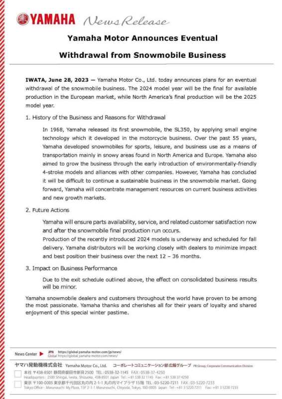
Earlier today, Yamaha Motor Co., the parent company of Yamaha Motor Canada LTD., released the notice below concerning the future direction of Yamaha’s Snowmobile Division. Bottom Line? We’re here for another 2 riding seasons in Canada, and the 2024s are already in production. We will support you with parts, warranty and service for years after should you decide to buy a Yamaha snowmobile for the 2024 and 2025 model years. We would like to thank our loyal customers for their passion towards snowmobile over the years and will celebrate the storied history of Yamaha snowmobiles together! If you have further questions about this announcement, a list of FAQs can be found here: https://www.yamaha-motor.ca/en/snowmobile-faq
-
new best western hotel - parry sound for early 2021
LuvMyViper replied to slomo's topic in Food & Lodging
I have taken care of the spammer... Thanks -
Or "warning, this job will make snowflakes melt"...
-
I'm thinking of separating the topics in this thread. Maybe name the new thread Aziz and friends.. any thoughts?
-
Maybe AlleyCat should change his name to the Cat Burglar
-
I just seen this picture on FB..

-
Welcome to the forum AlleyCat. I hope you enjoy yourself here. Rick
-
Just contact me if that happens
-
Forecast modelling and snowfall totals for the next 36 hours from CTV London https://london.ctvnews.ca/video?clipId=2639590&jwsource=cl
-
I'm seeing reports of thunder and lightning from all over the province (reports posted on the Instant Weather Ontario Storm Report group). Thunder just shook my house in Kitchener with lots of lightning..
-
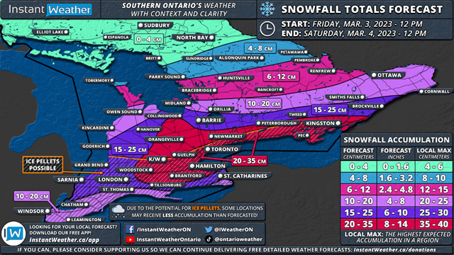
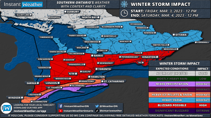
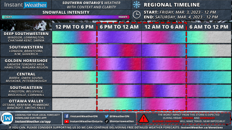
Potential Blizzard on the Horizon for Southern Ontario on Friday and Saturday; Up to 20–35cm of Snow Possible The concern is growing for what could be the most impactful system we’ve seen in Southern Ontario since last January when a potent blizzard left many stuck in widespread snowfall totals of 30-50cm. This upcoming storm has some similarities in terms of intensity and impacted areas compared to the January 2022 storm, but will likely fail to reach the 50+cm snowfall totals we saw last year. As we end off the first (partial) week of ‘meteorological spring’, it certainly won’t feel like that across Southern Ontario with an approaching system from the southwest expected to move into our region starting Friday afternoon. Current indications suggest that this system will deliver a significant dumping of snow across a wide swath of Southern Ontario including Southwestern Ontario, the Golden Horseshoe and into Eastern Ontario. Combined with strong wind gusts near 60-80km/h and intense snowfall rates, conditions will quickly deteriorate during the evening on Friday and continue overnight, into Saturday morning. Travel will be near impossible in the affected region from 6 PM on Friday and into pre-dawn on Saturday due to near-zero visibility and rapid snow accumulation. This may even lead to several highway and road closures around the Golden Horseshoe and into Southwestern Ontario where the worst conditions are expected. If you can, please stay off the roads starting Friday evening! There is some disagreement amongst the models on the exact snowfall totals with some differing on the track which could lead to more ice pellets mixing in along the Lake Erie and Lake Ontario shorelines. As a result, we may need to make some adjustments to the forecast by Friday afternoon based on the latest data. Either way, we are looking at a very impactful storm across Southern Ontario. Click here for the full forecast

-
I still don't get it.. Any more clues?
-
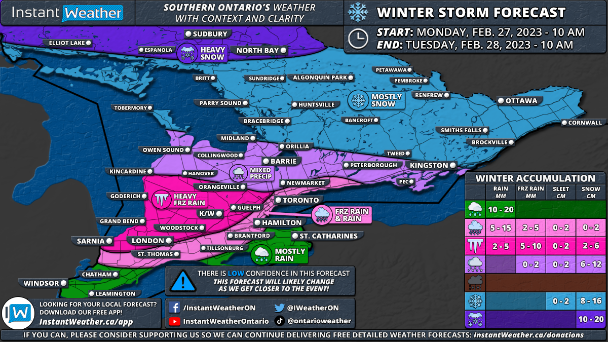
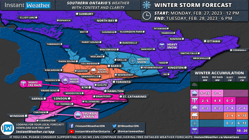
Instant Weather Ontario **February 27-28 WINTER SYSTEM UPDATE** ISSUED: Sunday, Feb. 26, 2023 - 11:30 PM Déjà vu, anyone? After reviewing the latest model data on the upcoming system for Southern Ontario, it looks like the colder air will win over across much of the region. We have adjusted our forecast moving the heavy snow zone further south into Central and Eastern Ontario. The freezing rain risk now covers an almost identical area as last week's storm with the heaviest icing expected across Sarnia through London and into the Hamilton/Niagara region. For the rest of Southwestern Ontario and into the GTA, we are looking at a mixed bag of precipitation including brief freezing rain, ice pellets and snow. The timeframe of this winter storm is fairly similar to our initial forecast with precipitation expected to start during the late morning hours in Deep Southwestern Ontario and spreading northward throughout the afternoon. It will likely begin as freezing rain in the Windsor/Chatham region before transitioning over to rain as temperatures rise above the freezing mark by the dinner hour. As mentioned, those in the Sarnia, London and Hamilton corridor will see more prolonged freezing rain during the afternoon and evening where the cold air is expected to hold on. We are also looking at a big impact on the evening commute as heavy snow and ice pellets affect the Golden Horseshoe starting during the late afternoon and continuing through the evening. There is still some disagreement on the exact temperature in this area, especially closer to the shoreline of Lake Ontario which would dictate the main precipitation type. Current indications suggest it should start as some heavy wet snow before transitioning over to ice pellets and even some freezing rain. Later in the evening and overnight, there is the potential that temperatures climb above the freezing mark around the shoreline leading to a transition over to rain. For Central and Eastern Ontario, snowfall will start during the early evening hours, continuing throughout the overnight and into Tuesday morning. Strong to damaging wind gusts may also accompany this system with gusts expected to reach 60-80km/h by late Monday and may even come close to 90km/h east of Lake Huron. This could lead to power outages in the areas that received heavy freezing rain earlier in the day and blowing snow for those further north. Everything will come to an end by Tuesday afternoon as the system moves out of our region. Total snowfall accumulation across Central and Eastern Ontario is expected to range from 10 to 15cm with some localized pockets (especially in the Ottawa Valley) picking up to 20cm. The icing from this event isn't expected to come near what we saw last week, but up to 4-8mm of ice accretion is possible in the hardest-hit region. Those in between the snow and freezing rain including much of Southwestern Ontario into the GTA will see a bit of everything so the exact totals are difficult to predict depending on the exact temperature. - Brennen P. P.S. If you can, please consider supporting us so we can continue delivering free detailed weather forecasts: https://instantweather.ca/donations
-
Instant Weather Ontario February Set to Go Out Like a Lion as Southern Ontario Is Targeted by Another Winter Storm on Monday Forecast: https://instantweather.ca/.../2023/2/25/son-winter-forecast Note: This is a preliminary forecast as there is some uncertainty on how long the cold temperatures will hold on which would affect the overall ice accretion. There is more confidence in the snowfall portion of this event so if we make any changes, it will likely be in Southwestern Ontario and the Golden Horseshoe once we get a better idea of how quickly the switchover will occur. Check back on Sunday for a more detailed forecast. Forecaster: Brennen Perry Published: Saturday, February 25, 2023 It has certainly been an active month across Southern Ontario regarding the weather as we’ve experienced almost all the seasons over the past few weeks. This includes temperatures on both extremes from wind chills in the -30s to spring-like temperatures well into the teens. It shouldn’t be a surprise that February is set to conclude with a bang across our region as yet another messy winter storm is on the horizon for Monday into Tuesday. Impacts will vary across the region from heavy snow in Central and Eastern Ontario to potentially several hours of freezing rain in the south. There is still some uncertainty regarding the exact intensity and timing of this storm so it’s quite likely there are some changes to the forecast as we get closer to Monday. At this point, it appears precipitation will start during the late morning or early afternoon on Monday in Deep Southwestern Ontario. With temperatures expected to be just above the freezing mark in the Windsor/Chatham area, it should come down in the form of rain. Total rainfall accumulation throughout this event will range from 10-20mm. As the precipitation spreads further north throughout the afternoon it will encounter some colder temperatures east of Lake Huron and into the Golden Horseshoe. As a result, a fairly expansive zone of freezing rain will develop and impact Sarnia, London, Goderich, K/W and Guelph along with parts of the GTA away from the shoreline throughout the afternoon and early evening. This could lead to icy road conditions just in time for the evening commute on Monday so plan to leave extra time to get to your destination and drive according to the conditions! The forecast gets tricky for those in the GTA around the Lake Ontario shoreline and into the Niagara region as temperatures will be very close to the freezing mark. Brief freezing rain is possible before it slowly transitions over to rain although if this transition is slower then more icing is possible. The Niagara region will likely see minimal freezing rain as the temperature is expected to rise faster there compared to other areas. While this system isn’t expected to be as significant as last week’s storm that brought heavy ice accretion from freezing rain, the time frame will be very similar as we see the worst impacts primarily during the evening across Southwestern Ontario and the Golden Horseshoe. Freezing rain will begin to transition over to rain in Southwestern Ontario as the temperature slowly climbs above the freezing mark during the evening and early overnight. Total ice accretion could range from 5-10mm in the hardest hit regions, but this should melt away fairly quickly unlikely last week which would limit the overall impact. It may still result in some localized power outages with a thin layer of ice developing on untreated surfaces including trees and power lines. Further north across Central and Eastern Ontario, we are looking at mostly snowfall with ice pellets mixed in for regions south of Lake Simcoe. Snow will start during the late afternoon and continue throughout the evening and overnight. Total snowfall accumulation is expected to range from 6 to 16cm with the highest totals in the more northern parts of our region. Those in Northeastern Ontario including Elliot Lake, Sudbury and North Bay could see up to 20cm of snow. We expect to see the snow come to an end by the noon hour on Tuesday. As mentioned, this is a preliminary forecast as there is some uncertainty on how long the cold temperatures will hold on which would affect the overall ice accretion. There is more confidence in the snowfall portion of this event so if we make any changes, it will likely be in Southwestern Ontario and the Golden Horseshoe once we get a better idea of how quickly the switchover will occur. Check back on Sunday for a more detailed forecast.

-
Lots of phone calls, emails and social media postings.. And asking why this is happening so it doesn't happen again.. Demand they send groomers north asap.. Come up with a cool name eg. Save The North and coordinate our efforts involving all the snowmobile forums... And calls to a few newspapers/news programs also gets quick result! An old fashion.........
-
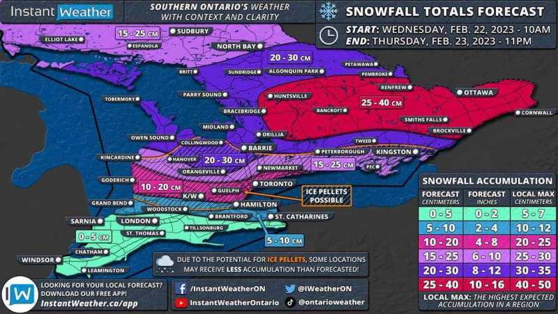
Good morning! Here’s your snowfall forecast for today and Thursday. Read more here: https://instantweather.ca/articles/2023/2/21/son-ice-snow-forecast The focus on the snow will be in Eastern Ontario where the Ottawa Valley is likely to see 25-40cm of accumulation by the end of Thursday. It should be noted that some models are showing less moisture making that far north so the potential for this region to underperform the forecast isn’t out of the question. For the rest of Eastern and Central Ontario, snowfall totals will end up somewhere around 15-30cm. As we go south of Lake Simcoe the snowfall accumulation will become less clear as ice pellets mix in and reduce the overall snow total. We are looking at 10-20cm from Goderich and into the Toronto region although that could end up on the lower end due to the ice pellets. And less than 10cm of snow is expected through Deep Southwestern Ontario and north of Lake Erie where freezing rain is the concern. - Brennen
-
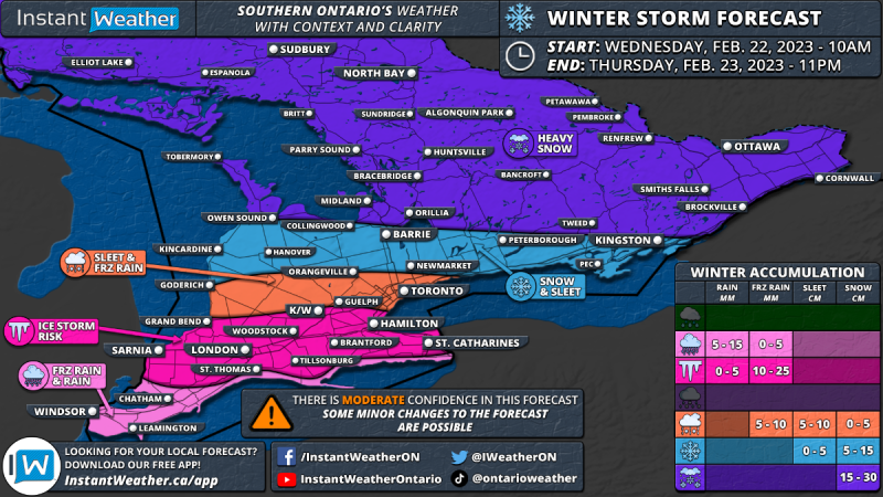
Below is the latest forecast from Instant Weather Ontario. Good evening! We've got a quick update and adjustment to our map for the upcoming winter storm to impact Southern Ontario between Wednesday and Thursday. ZOOMABLE MAP: https://scontent.fyto1-2.fna.fbcdn.net/.../332306427... Based on the latest model data from today, we are noticing a slight northern trend in the track of this system. This means that the heavy snow shifts towards regions north of Lake Simcoe while the GTA is now firmly in the ice pellet and freezing rain mix. For the ice storm threat, the highest concern is from Sarnia through London into K/W and Hamilton. These areas could see over 12 hours of steady icing starting Wednesday late morning and continuing through to Thursday. With ice accretion ranging from 10-25mm combined with wind gusts of 50-70km/h, we will likely see some power outages in the hardest-hit regions. We are also seeing some models mixing in rain for Deep Southwestern Ontario (Windsor, Chatham etc.) and along the Lake Erie shoreline. This will ultimately come down to a fraction of a degree with the temperature in determining the precipitation type making this a very tricky forecast. We do know that *someone* will see significant freezing rain from this event, but we can't pinpoint those locations just yet. The overall freezing rain risk should become clearer overnight into tomorrow as more of the higher-resolution models come into range, allowing us to analyze the micro-level dynamics. More details shortly!